Selling a vineyard, winery, or rural wine country property involves more than finding the right buyer. Before a transaction can move forward, buyers, lenders, title companies, and advisors often need a clear understanding of the property’s boundaries, access, easements, improvements, and existing site conditions.
That is where updated surveys and maps can make a major difference.
Boundary questions, unclear easements, outdated parcel information, access issues, and unrecorded improvements can all create delays during due diligence. In some cases, these issues may affect negotiations, financing, title review, or the overall timeline of a sale.
For vineyard and winery owners, accurate mapping can also help tell the full story of a property. Beyond basic parcel lines, updated survey and GIS information can help document vineyard blocks, roads, utilities, irrigation infrastructure, buildings, topography, and other features that contribute to the property’s use, value, and long-term potential.
Common due diligence items buyers may look for include:
• Clearly defined property boundaries
• Easements, rights-of-way, and access points
• Existing structures, roads, fences, and utility locations
• Vineyard block layout and site characteristics
• Topography, drainage, and other land features
• Records that support title, financing, planning, or future development
Addressing these details before listing can help owners avoid last-minute surprises, support a smoother transaction, and provide buyers with greater confidence in what they are evaluating.
Ray Carlson & Associates works with wineries, vineyards, landowners, and wine industry properties throughout the North Bay, providing professional land surveying, mapping, GIS, ALTA surveys, and vineyard-related mapping services.
Whether preparing for a sale, evaluating a purchase, or simply wanting a better understanding of your property, updated survey and mapping information can be a valuable place to start.
Contact Ray Carlson & Associates to learn how accurate land data can support your next property decision.
When it comes to selling vineyard or winery property, it’s not just about location—it's about clarity, compliance, and confidence. That’s where Ray Carlson & Associates comes in.
With more than 40 years of experience in surveying and land consulting, Ray Carlson & Associates helps wine industry professionals protect their investment and maximize value by providing comprehensive, high-precision land surveys. Whether you're selling your estate or subdividing a large property, a survey is more than a technical requirement—it’s a strategic tool.
Why a Land Survey Matters When Selling
Selling a vineyard or winery often involves complex property features—easements, access roads, water rights, and unique zoning requirements. A boundary dispute or an overlooked flood zone designation can delay or derail a deal.
Ray Carlson & Associates offers a suite of services to ensure your transaction goes smoothly:
Boundary and Easement Surveys: Clarify legal property lines and access rights.
Topographic & ALTA/NSPS Surveys: Critical for title insurance and due diligence.
FEMA Flood Zone & Elevation Certificates: Help buyers understand risk and insurance needs.
As-Built Surveys & Parcel Mapping: Provide accurate documentation of existing conditions and potential land splits.
Technology-Driven Precision
Using cutting-edge drone (UAV) technology, GPS systems, and Geographic Information Systems (GIS), Ray Carlson & Associates delivers not just maps, but actionable insights. Their aerial surveys, 3D fly-throughs, and vineyard-specific mapping services are especially valuable to buyers seeking clarity on what they’re purchasing.
Supporting the Whole Transaction
The team also supports real estate transactions through consulting and expert witness services—whether it's backing up a title report or providing historical aerial photos for development research.
Designed for the Wine Industry
With vineyard as-built mapping, development planning, and regulatory compliance documentation, their services are tailored for the unique needs of vineyard and winery properties. That’s why top developers, brokers, and landowners in wine country trust Ray Carlson & Associates for their mapping needs.
Thinking of selling? Make your first call the one that sets the foundation for a smooth and profitable transaction. Ray Carlson & Associates is ready to help you map the way forward.
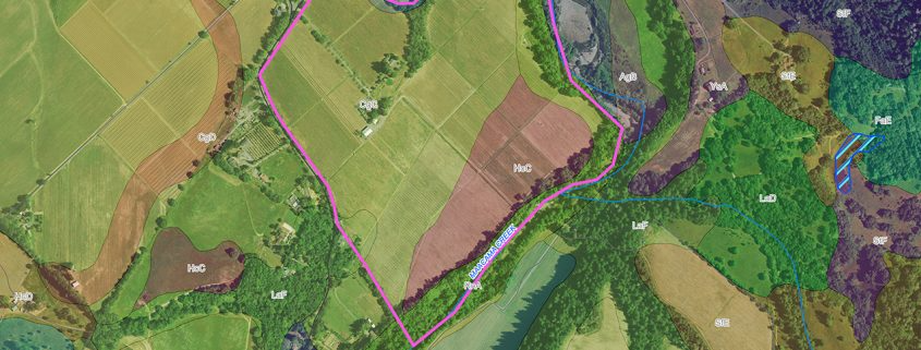
The Geographic Information System Advantage
The Ray Carlson & Associates, Inc. business model includes an experienced Geographic Information System (GIS) division which serves to enhance the company’s leadership position among land surveying companies. A geographic information system is a blending of software, hardware, and data for capturing, managing, analyzing, and displaying all forms of geographically referenced information. Layers and tables of information are combined to provide a framework in order to plan, model and make better decisions. Your purpose dictates which layers of information are used.
Internally our GIS Division tracks all jobs through a customized GIS-enabled database which allows for increased data access, tracking of submittals and efficiency among adjacent jobs with the integration of thousands of job records. As GIS improves our surveying, so the combination of high precision GPS and land expertise of our surveying professional counterparts allows us to, in turn, to be considered uniquely advantageous among GIS consultants.
In addition to supporting surveying and mapping services, GIS at Ray Carlson and Associates, Inc. offers considerable benefits to vineyard owners. GIS brings a series of new and highly innovative technologies to industry and agriculture for work planning, inventory control, and site analysis solutions. With seasoned vineyard and certified GIS professionals, we have started from the ground up to build the only verifiable vineyard As-Built mapping system giving you vine level management of your water system and drainage.
Your Management Decisions Are Only as Good as Your As-Built Mapping.

In today’s wine industry, effective vineyard and winery management requires more than just good farming practices—it requires data. Geographic Information Systems (GIS) have become a powerful tool for wine growers, enabling them to track, analyze, and manage data on everything from vine health to irrigation systems. Ray Carlson & Associates has been leveraging GIS technology to help clients manage their vineyards more efficiently and with greater precision.
What Is GIS?
GIS (Geographic Information System) is a framework used to collect, manage, and analyze spatial and geographic data. In the context of vineyards and wineries, GIS helps manage land-based data that can inform decisions on everything from crop yields to vineyard design.
Why GIS Matters for Vineyard Management
For vineyard owners, GIS provides a way to visualize complex data and make informed decisions. Some of the ways GIS can be used in vineyard management include:
- Mapping Vineyard Features: GIS helps map key features like irrigation systems, soil types, vine spacing, and even weather patterns, allowing owners to optimize vineyard layouts.
- Tracking Soil and Crop Data: Soil conditions can vary across a vineyard, and GIS can help track these variations to optimize vine health and productivity.
- Water Management: GIS makes it easier to track water usage, monitor irrigation systems, and ensure that water is being used efficiently—critical in areas with water scarcity issues.
Integrating GIS with Other Technologies
GIS can also be integrated with other technologies like GPS and drone surveys. Ray Carlson & Associates uses this integration to provide vineyard owners with highly accurate, up-to-date information that can be used to:
- Plan irrigation systems and drainage
- Track seasonal yield and vine growth
- Identify areas of the vineyard that require attention or improvement
How GIS Improves Decision-Making
With GIS, vineyard managers can make better, data-driven decisions. For example, if a particular section of the vineyard has been yielding fewer grapes over time, GIS data can help identify the underlying factors, such as poor soil conditions or inadequate irrigation. Similarly, GIS can be used to track the effectiveness of different farming practices and adjust them accordingly.
Ray Carlson & Associates: GIS Experts for the Wine Industry
At Ray Carlson & Associates, GIS is just one of the many tools we use to help our clients manage their vineyards effectively. Our team has years of experience working with vineyards in Napa, Sonoma, and surrounding areas, and we understand the specific needs of the wine industry.
Every vineyard tells a story, but some chapters aren’t easy to read. Hidden beneath the surface—or buried in old records—are secrets that can affect your land’s value, your ability to develop, or even your next harvest.
Whether you inherited your vineyard, bought it as-is, or have managed it for years, uncovering these hidden details is crucial. That’s where Ray Carlson & Associates steps in, combining decades of experience with cutting-edge technology and deep historical research to reveal what your vineyard isn’t telling you.
What Kinds of Secrets Are We Talking About?
- Unrecorded Easements: Access rights or utility corridors that don’t appear in your current deed but can limit how you use your land.
- Boundary Discrepancies: Old surveys or informal boundaries that don’t match legal property lines, causing confusion or disputes with neighbors.
- Hidden Utilities: Underground water lines, irrigation pipes, or cables not documented on maps but critical to operations and future planning.
- Flood Zones & Environmental Risks: Areas prone to flooding or other hazards that might affect insurance and compliance.
- Historical Land Use: Previous land activities or ownership issues that could impact zoning or development permissions.
Digging Deeper: The Ray Carlson Difference
Ray Carlson & Associates doesn’t just provide a survey—they offer a full investigation. Their team leverages:
- Advanced GIS Mapping: Layering past and present data to reveal changes and inconsistencies
- Drone and GPS Technology: To capture precise current conditions that support research findings
- Expert Witness Services: Helping clients navigate disputes or legal questions with clarity and authority
Why Does This Matter?
Ignoring these hidden factors can lead to costly surprises: stalled sales, legal battles, or expensive rework during development or harvest. Finding these “secrets” early means you can plan effectively, avoid risks, and unlock the full potential of your vineyard.
Take Control of Your Land’s Story
If your vineyard has secrets, it’s time to find them before they find you. Ray Carlson & Associates helps wine industry professionals see the full picture—past, present, and future—to protect their investment and make confident decisions.
Owning a vineyard is often a dream fulfilled. For many, it comes through inheritance or a generational land transfer—something that feels personal, informal, and steeped in trust. But when it comes to land ownership, tradition doesn’t always align with legal boundaries. And assumptions can turn into very real (and very expensive) surprises.
Ray Carlson & Associates has seen it all: vines planted over property lines, unrecorded easements that limit development, and inherited parcels with boundary lines that haven’t been surveyed in decades. If you're managing—or selling—a vineyard you didn’t originally design or develop, a professional land survey might be the most important tool you didn’t know you needed.
Old Maps, New Problems
Vineyards passed down through generations often rely on outdated parcel maps, oral agreements, or informal knowledge of the land. That might have worked in the past—but it doesn’t fly with modern buyers, regulators, or insurers. A boundary or easement issue can stall a transaction, cause conflict with neighbors, or restrict what you can legally build, plant, or sell.
Ray Carlson & Associates uses modern GPS technology, drone imaging, and Geographic Information Systems (GIS) to provide precise, legally sound documentation of your land. Their surveys aren’t just about drawing lines—they help you understand exactly what you own, what you can do with it, and how to protect its value.
Common Surprises in Inherited Vineyards
- Encroachment: Vines, fencing, or infrastructure crossing onto neighboring parcels
- Unrecorded Easements: Utility or access routes never formally documented
- Inaccurate Acreage: What’s on the deed may not reflect what’s actually usable
- Missing Records: Title issues that only surface during development or sale
A Survey Today Avoids Trouble Tomorrow
Before you build that barn, dig a new well, or even harvest this season’s fruit, it’s worth asking: Do I really know what I own? A comprehensive land survey helps you move forward with confidence—whether your goal is to sell, develop, or simply steward the vineyard for the next generation.
Ray Carlson & Associates has been helping landowners in wine country uncover the full story of their land for over 40 years. With a deep bench of historical records, cutting-edge tech, and a team that understands the complexities of vineyard properties, they’re the go-to experts for land clarity and compliance.
Need a second opinion on your boundaries?
Reach out to Ray Carlson & Associates to schedule a survey—or to dig into the history of your land.
Starting a new vineyard or expanding an existing one is a complex and costly process. Without accurate land data, vineyard development projects can face delays, legal disputes, and unforeseen costs. That’s why land surveys are an essential first step for any vineyard development project.
At Ray Carlson & Associates, we’ve been helping vineyard owners in Sonoma, Napa, and surrounding areas navigate the challenges of vineyard development for over four decades. Here’s why accurate land surveys are so important.
Planning Your Vineyard Development
The first step in vineyard development is determining whether the land is suitable for growing grapes. Accurate surveying data allows vineyard managers and developers to evaluate key factors such as:
Topography: The shape and slope of the land will influence water drainage and irrigation planning.
Soil Quality: Knowing the soil composition and its ability to support grapevines is crucial.
Sun Exposure: The orientation of the land can affect vine growth and grape quality.
Without precise surveying data, these factors are harder to assess, and mistakes can be costly.
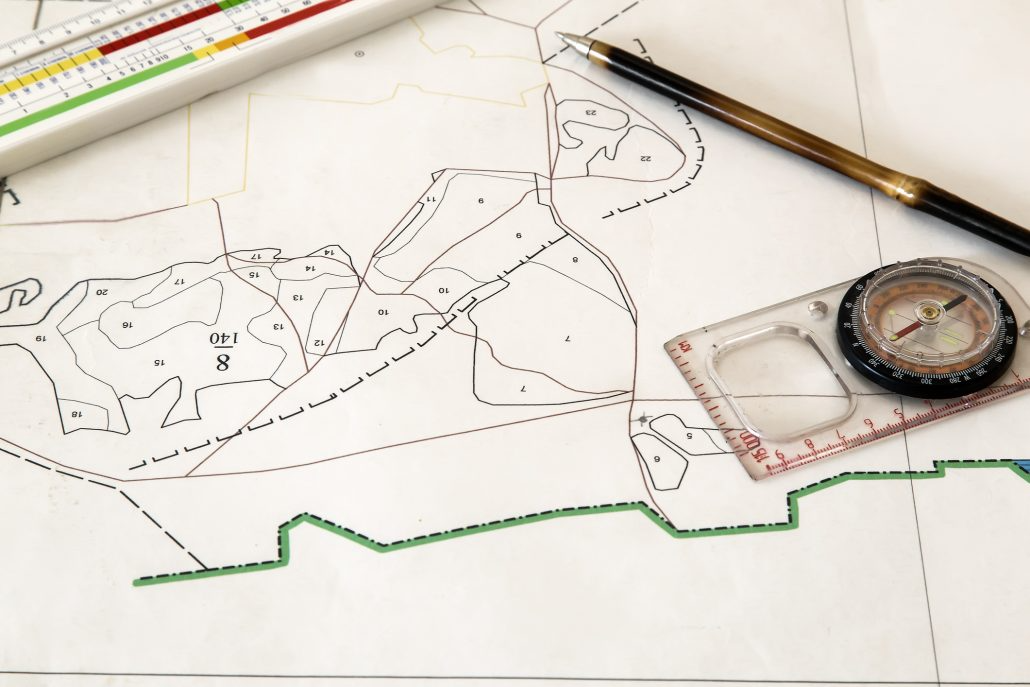
Types of Surveys Needed for Vineyard Development
For vineyard development, several types of surveys are typically required:
Topographic Surveys: These surveys measure the contours of the land, allowing for optimal irrigation planning, road placement, and vine row layout.
Boundary Surveys: A clear understanding of the property’s boundaries ensures that development stays within legal limits.
Environmental Surveys: Some areas may require environmental assessments to ensure that the development doesn’t impact local ecosystems or violate zoning laws.
The Role of GPS and GIS in Vineyard Planning
Ray Carlson & Associates uses cutting-edge GPS and GIS technology to gather accurate data for vineyard development. GIS (Geographic Information System) allows for detailed mapping of features like irrigation lines, vine spacing, and even crop yield data. This makes it easier to plan for new vineyard sections, ensure that water resources are efficiently used, and track long-term productivity.
Avoiding Common Pitfalls
Vineyard development projects often encounter delays or complications when land surveys are not conducted properly. For example, misinterpreting boundary lines can lead to encroachments, disputes with neighbors, or delays in obtaining permits. Comprehensive surveys conducted by Ray Carlson & Associates reduce the risk of such issues.
For vineyard owners looking to build or expand, the importance of accurate surveys cannot be overstated. At Ray Carlson & Associates, we have the expertise and tools necessary to ensure that your vineyard development project proceeds smoothly and efficiently.
Contact Ray Carlson & Associates to Begin Your Vineyard Development With Accurate Land Surveys!
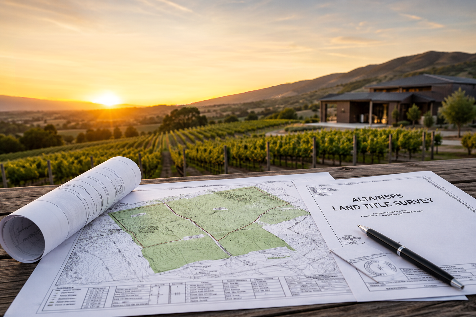
When it comes to buying or selling land, especially in the wine industry, it's crucial to ensure that property boundaries are clearly defined. One of the most important tools for achieving this is an ALTA/NSPS survey - an industry standard for real estate transactions.
Ray Carlson & Associates specializes in provided detailed ALTA surveys for wineries, vineyards and other wine industry properties. Understanding what an ALTA survey entails and why it's important can help ensure that your property transactions proceed smoothly.
What is an ALTA Survey?
An ALTA/NSPS survey is a type of land survey that adheres to specific standards set by the American Land Title Association (ALTA) and the National Society of Professional Surveyors (NSPS). These surveys are typically required for real estate transactions, particularly those involving title insurance. They provide a detailed report of the property's boundaries, improvements, easements, and any other factors that may affect ownership.
Why Are ALTA Surveys Important for the Wine Industry?
The wine industry, with its vast vineyards and unique land requirements, relies heavily on ALTA surveys to ensure that property boundaries are clearly defined. These surveys are crucial in preventing future disputes over land ownership, access, and rights. Whether buying a new piece of vineyard property or selling part of a whine estate, an ALTA survey can prevent costly legal issues.
For wineries and vineyards, the accuracy of land boundaries is essential. Mistakes in boundary determinations could lead to:
- Disputes over property lines: Incorrect survey data can lead to conflicts with neighboring landowners over land ownership.
- Title Insurance Problems: Without an accurate survey, title insurance companies may not be willing to issue policies, which could delay or derail a transaction.
- Zoning and Environmental Concerns: ALTA surveys also help ensure compliance with zoning laws and environmental regulations, which is critical in the wine industry.
Key Components of an ALTA Survey
An ALTA Survey typically includes the following elements:
- Boundary Lines: Precise measurement of property boundaries and corners.
- Improvements: Identification of any structures on the property, such as buildings, roads,fences, and utility lines.
- Easements and Rights of Way: Documentation of any rights that other parties may have to use the property for specific purposes, such as access roads or utility lines.
- Topographic Information: Elevation data and terrain features, which are especially important for vineyards where slope and drainage are critical factors.
- Access Points: Locations of roads and access points to the property, ensuring that there are no disputes over entry rights.
How Ray Carlson & Associates Can Help
With Ray Carlson & Associates handling your ALTA surveys, you can rest assured that your land transaction will be based on accurate, up-to-date data. Their decades of experience in the North Bay area have made them experts in the specific needs of the wine industry, and they understand the importance of getting it reight the first time.
Whether you're buying a new vineyard or selling an existing wine estate, Ray Carlson & Associates provides the reliable survey data you need to navigate the complexities of land transactions.
Contact Ray Carlson & Associates to Get Started with Your ALTA Survey Today
In the Wine Industry, precision is key. Whether it's for developing new vineyard sites, expanding existing operations, or managing irrigation systems, having accurate land data is critical. This is where modern surveying technology comes into play.
Ray Carlson & Associates has been at the forefront of using these cutting-edge technologies to provide accurate and efficient land surveys for the North Bay wine industry, including vineyards in Sonoma, Napa, and beyond.
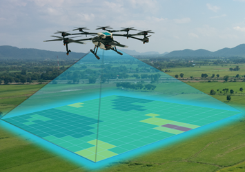
The Role of Drones in Surveying
Drones - or unmanned aerial vehicles (UaVs) - have taken land surveying to new heights. With high-definitiion cameras and GPS-enabled flight paths, drones capture precise aerial images that can be stitched together to create detailed topographic maps and 3D models. These models help vineyard owners visualize their land in ways that were once impossible with traditional surveys.
Using drones to map vineyard properties offers several advantages:
- Efficient Coverage: Drones can quickly cover large areas of land that might otherwise be difficult or costly to survey on foot.
- Detailed Aerial Imagery: High-resolution aerial images allow for better visualization of the land's topography, including slopes, water drainage, and potential hazards.
- 3D Modeling: Aerial surveys can generate 3D models of the land, making it easier to plan for new vineyard layouts, irrigation systems, and other infrastructure.
How This Technology Benefits Vineyards
For vineyards, using GPS and drones to survey land is not just about precision - it's about gaining a deeper understanding of the property. Whether you're designing a new vineyard or managing an existing one, accurate data abou tthe land's contours, irrigation systems, and growth potential can make a huge difference.
- Optimal Land Use: With accurate topographic maps, you can decide where to plant grapevines based on the best land conditions.
- Irrigation and Drainage Planning: Knowing the exact slope and contours of your vineyard helps plan an efficient irrigation system, reducing water waste and optimizing vine health.
- Increased Efficiency: Drones make it possible to survey and collect data from hard-to-reach or large areas, reducing the amount of time it takes to get results.
Why Ray Carlson & Associates?
With over 40 years of surveying experience in Sonoma, Napa, and surrounding counties, Ray Carlson & Associates has developed a deep understanding of the land - and the technology used to map it. Our surveys offer unparalleled accurace and efficiency, ensuring that vineyard owners can make the best decisions about their properties.
Contact Ray Carlson & Associates today to see how our surveying can benefit your vineyard.

Ray Carlson & Associates: Mapping a Better World
Consulting Services Time and Cost Savings - Our meticulous and efficient approach, combined with our strong relationships with public agencies, helps you