March 25, 2020

Delivering powerful vineyard insights to your inbox
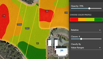
During this unprecedented time, we at VineView are working to improve the efficiency of your vineyard operations, giving you the ability to prioritize limited labor resources through our precise vineyard metrics and zone maps.
Use our pure canopy zone maps to:
- Prioritize canopy management including precision shoot and leaf removal
- Create targeted sampling plans for minimum effort and maximum accuracy
- Plan nutrition programs
- Account for missing vines
- Stratify harvest
 As essential support for agricultural operations, we are still able to fly and provide you with unparalleled insights from above. Contact melissa@vineview.com for a demo.
00